Scotland's Indicators - Soil Sealing
Published: 2023
Soil sealing creates an impervious layer, which damages the natural soil structure and compromises its ability to function. This damage can adversely affect biodiversity, as well as putting people and property at risk. Plants and animals may not be able to access sufficient nutrients, water and shelter in and around sealed area. This also leads to a degradation of the soil health through change to its physical, chemical and biological properties. This indicator provides details on the extent of soil sealing across Scotland.
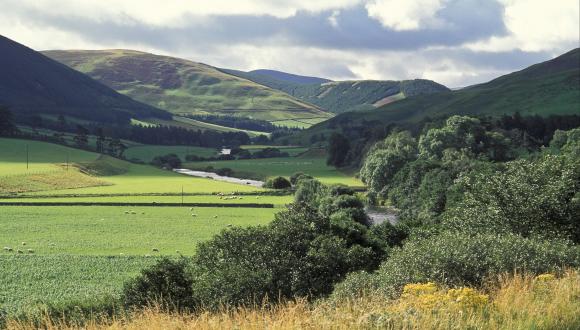
The magnitude of the impact of sealing is linked to the quality or health of the original soil and its land use, with loss of function more pronounced when undeveloped land is covered. Healthy soils provide us with a wide range of benefits. Some of these benefits are obvious, like growing food, while many are less clear, like filtering water, reducing flood risk and influencing climate. Scotland’s soils hold more than 3,000 megatonnes of carbon, around 60% of which is held in deep peat soils. When soils are damaged by natural or human processes, they may no longer be able to provide some or all of these services that are essential to support our ecosystems. Soil sealing, the cover of soil by surfaces such as concrete or tarmac, is one of the ways in which humans can damage soil’s ability to carry out these functions. The extent of our built landscape can be used as a proxy for estimating the extent of soil sealing. Settlements, transport, energy and communications infrastructure, as well as industry and housing are all components of our built landscape.
How the data are collected
This is an indicator of built environment pressures derived from analysis of Ordnance Survey MasterMap (a commercially available map and database of fixed features) and NatureScot records of windfarm sites. It includes national coverage (ha) and the distribution of built development pressures on 1km grid squares for the whole of Scotland and for each local authority.
The level of soil sealing is typically higher in areas with a long history of settlement or industry, though some of these areas also have important green spaces, which help support nature.
Description of current indicator status
Overall the percentage of soil sealing in Scotland has risen from 1.55% in 2009 to 1.89% in 2020 (Figure 1.). The annual rate of increased soil sealing between 2009 and 2020 is low within each individual unitary authority (<0.10%).
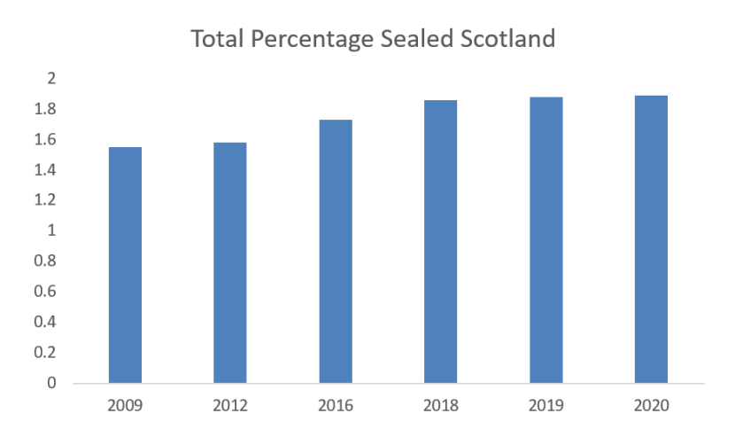
Figure 1. Total percentage of Soil Sealing in Scotland 2009 to 2020
Click for a full description
Bar chart showing the percentage area of Scotland soil sealing for 2009, 2012, 206, 208, 2019 and 2020.
Soil Sealing at the Unitary Authority Scale
The area of Scotland’s unitary authorities varies markedly (see Table 1). Highland covers the largest area at around 2.6 million hectares and Dundee City the lowest (6000 hectares). The percentage of the total area sealed also varies, Western Isles having the lowest (0.57% sealed in 2020) and Glasgow City the highest (39.14% in 2020). The total areas involved reveals a slightly different picture (see Figure 2), Highland has the largest area sealed, and has seen the greatest sealed area increases since 2009. This reflects the expansion of Inverness and the surrounding towns with housing and several new roads.
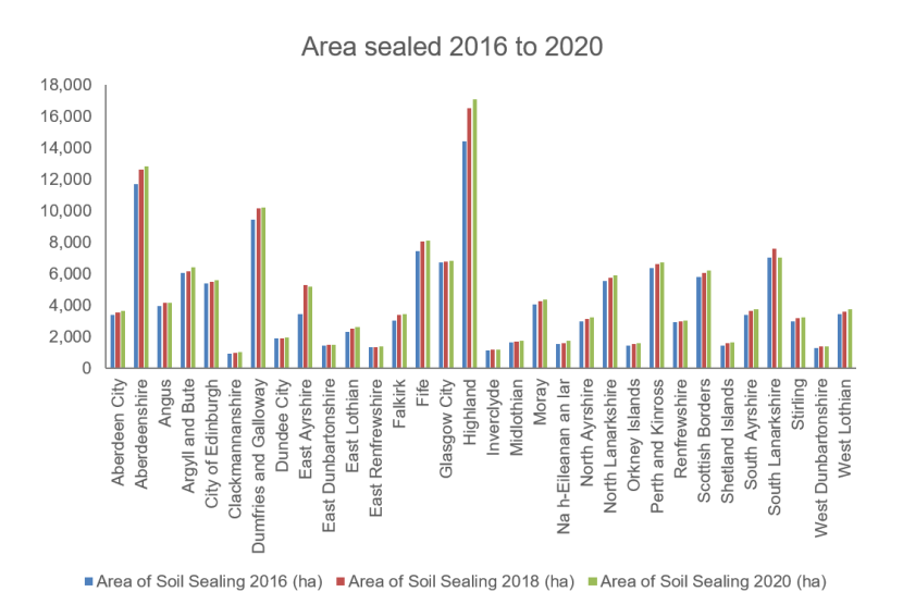
Figure 2. Area sealed by Unitary Authority 2016 to 2020
Click for a full description
Bar chart showing the area (hectares) sealed by Scottish Unitary Authority for 2016, 2018 and 2020.
No area showed decreases from 2009 to 2020 in the total area sealed, but focussing on mineral workings highlights some of the important restoration projects, such as in South Lanarkshire and East Ayrshire. South Lanarkshire has undertaken restoration of former mineral workings of around 1000 hectares (from 2018 to 2020).
Restoration Projects
The Coalfield Communities Landscape Partnership (CCLP) is a Heritage Lottery funded initiative led by East Ayrshire Council focused on Cumnock and the surrounding East Ayrshire coalfields. The CCLP provides an opportunity to reinvigorate life in the landscape based on the lessons of the past, life in the present and a vision of life in the future. The Coalfields to Wildwoods project seeks to enhance the landscape, improve biodiversity and create education and training opportunities. The project will help empower local people and give them a direct stake in their local landscape. It is training them in the propagation of native pioneer plant species including local rarities such as aspen, juniper and montane willow. Citizens are also setting up a network of small local plant nurseries to provide the resources required to initiate community growing. The aim is to assist the restoration of open cast sites and improve overall woodland cover within the project area.
The Scottish Land Commission identifies areas of derelict land across Scotland. Through their task force several projects have been undertaken benefitting nature and people. These include the Canal and North Gateway project in Glasgow. The project has two parts along the canal corridor between Firhill and Port Dundas. The Clay Pits Local Nature Reserve (LNR) project is changing a 10ha derelict site into a Local Nature Reserve, thus improving access and areas to watch wildlife. The other part of the project provides the surface water drainage solution for the regeneration of key vacant and derelict sites including Sighthill, Hamiltonhill and Cowlairs through dynamically managing the water level in the canal to provide flood storage. This is an exemplar project where blue-green infrastructure underpins regeneration.
Updates (see attached spreadsheet)
The indicator will next be updated in 2024.
| Unitary Authority (UA) | Area of UA to MHWS* (Ha) | Area of Soil Sealing 2009 (ha) | % of Soil Sealing (2009) | Area of Soil Sealing 2012 (ha) | % of Soil Sealing (2012) | Area of Soil Sealing 2016 (ha) | % of Soil Sealing (2016) | Area of Soil Sealing 2018 (ha) | % of Soil Sealing (2018) | Area of Soil Sealing 2019 (ha) | % of Soil Sealing (2019) | Area of Soil Sealing 2020 (ha) | % of Soil Sealing (2020) |
|---|---|---|---|---|---|---|---|---|---|---|---|---|---|
| Aberdeen City | 18,559.37 | 3,114.77 | 16.78 | 3,179.67 | 17.13 | 3,403.53 | 18.34 | 3,580.13 | 19.29 | 3,613.01 | 19.47 | 3,658.71 | 19.71 |
| Aberdeenshire | 631,791.71 | 10,504.34 | 1.66 | 10,715.39 | 1.70 | 11,729.54 | 1.86 | 12,627.25 | 2.00 | 12,670.45 | 2.01 | 12,838.04 | 2.03 |
| Angus | 218,510.54 | 3,611.70 | 1.65 | 3,653.28 | 1.67 | 3,983.77 | 1.82 | 4,161.19 | 1.90 | 4,177.15 | 1.91 | 4,185.76 | 1.92 |
| Argyll and Bute | 700,619.95 | 5,316.90 | 0.76 | 5,354.96 | 0.76 | 6,041.94 | 0.86 | 6,188.77 | 0.88 | 6,244.95 | 0.89 | 6,400.72 | 0.91 |
| City of Edinburgh | 26,335.16 | 5,089.66 | 19.33 | 5,139.88 | 19.52 | 5,375.94 | 20.41 | 5,505.24 | 20.90 | 5,565.61 | 21.13 | 5,588.85 | 21.22 |
| Clackmannanshire | 15,897.22 | 899.62 | 5.66 | 909.85 | 5.72 | 928.32 | 5.84 | 1,016.04 | 6.39 | 1,024.12 | 6.44 | 1,024.96 | 6.45 |
| Dumfries and Galloway | 643,644.46 | 8,347.46 | 1.30 | 8,549.07 | 1.33 | 9,470.95 | 1.47 | 10,162.05 | 1.58 | 10,230.11 | 1.59 | 10,222.06 | 1.59 |
| Dundee City | 5,983.02 | 1,837.92 | 30.72 | 1,859.29 | 31.08 | 1,915.03 | 32.01 | 1,935.83 | 32.36 | 1,937.89 | 32.39 | 1,944.16 | 32.49 |
| East Ayrshire | 127,034.20 | 2,777.47 | 2.19 | 2,914.21 | 2.29 | 3,470.20 | 2.73 | 5,273.78 | 4.15 | 5,147.80 | 4.05 | 5,183.30 | 4.08 |
| East Dunbartonshire | 17,448.90 | 1,312.02 | 7.52 | 1,326.32 | 7.60 | 1,471.29 | 8.43 | 1,504.47 | 8.62 | 1,511.11 | 8.66 | 1,511.78 | 8.66 |
| East Lothian | 67,917.89 | 2,111.21 | 3.11 | 2,168.43 | 3.19 | 2,327.59 | 3.43 | 2,545.52 | 3.75 | 2,636.27 | 3.88 | 2,653.04 | 3.91 |
| East Renfrewshire | 17,424.95 | 1,173.39 | 6.73 | 1,195.08 | 6.86 | 1,346.82 | 7.73 | 1,342.87 | 7.71 | 1,355.35 | 7.78 | 1,383.91 | 7.94 |
| Falkirk | 29,736.56 | 2,793.61 | 9.39 | 2,849.38 | 9.58 | 3,056.85 | 10.28 | 3,378.5 | 11.36 | 3,422.5 | 11.51 | 3,438.13 | 11.56 |
| Fife | 132,536.29 | 6,797.44 | 5.13 | 6,913.36 | 5.22 | 7,453.61 | 5.62 | 8,042.59 | 6.07 | 8,101.22 | 6.11 | 8,136.73 | 6.14 |
| Glasgow City | 17,462.13 | 6,368.87 | 36.47 | 6,453.57 | 36.96 | 6,733.00 | 38.56 | 6,771.10 | 38.78 | 6,793.76 | 38.91 | 6,835.50 | 39.14 |
| Highland | 2,615,955.29 | 12,879.90 | 0.49 | 12,950.75 | 0.50 | 14,414.20 | 0.55 | 16,549.47 | 0.63 | 16,872.87 | 0.64 | 17,089.48 | 0.65 |
| Inverclyde | 16,194.88 | 1,119.92 | 6.92 | 1,138.08 | 7.03 | 1,167.87 | 7.21 | 1,184.90 | 7.32 | 1,184.14 | 7.31 | 1,183.37 | 7.31 |
| Midlothian | 35,527.16 | 1,387.45 | 3.91 | 1,433.75 | 4.04 | 1,653.64 | 4.65 | 1,705.13 | 4.80 | 1,737.80 | 4.89 | 1,747.63 | 4.92 |
| Moray | 223,721.80 | 3,576.17 | 1.60 | 3,645.44 | 1.63 | 4,058.65 | 1.81 | 4,260.56 | 1.90 | 4,368.90 | 1.95 | 4,392.68 | 1.96 |
| Na h-Eileanan an Iar | 309,662.43 | 1,379.16 | 0.45 | 1,409.30 | 0.46 | 1,552.80 | 0.50 | 1,621.17 | 0.52 | 1,625.12 | 0.52 | 1,774.72 | 0.57 |
| North Ayrshire | 88,527.62 | 2,741.45 | 3.10 | 2,783.09 | 3.14 | 2,986.83 | 3.37 | 3,146.97 | 3.55 | 3,186.01 | 3.60 | 3,232.11 | 3.65 |
| North Lanarkshire | 47,230.91 | 5,081.07 | 10.76 | 5,025.81 | 10.64 | 5,575.41 | 11.80 | 5,748.24 | 12.17 | 5,861.98 | 12.41 | 5,890.03 | 12.47 |
| Orkney Islands | 101,503.27 | 1,300.37 | 1.28 | 1,335.30 | 1.32 | 1,440.27 | 1.42 | 1,580.84 | 1.56 | 1,585.55 | 1.56 | 1,627.26 | 1.60 |
| Perth and Kinross | 538,375.95 | 5,934.56 | 1.10 | 5,963.18 | 1.11 | 6,351.40 | 1.18 | 6,624.76 | 1.23 | 6,671.20 | 1.24 | 6,749.52 | 1.25 |
| Renfrewshire | 26,148.77 | 2,741.37 | 10.48 | 2,751.60 | 10.52 | 2,935.91 | 11.23 | 3,016.22 | 11.53 | 3,035.84 | 11.61 | 3,057.90 | 11.69 |
| Scottish Borders | 473,946.30 | 5,049.85 | 1.07 | 5,168.17 | 1.09 | 5,792.88 | 1.22 | 6,052.18 | 1.28 | 6,194.64 | 1.31 | 6,234.04 | 1.32 |
| Shetland Islands | 146,848.34 | 1,283.78 | 0.87 | 1,340.92 | 0.91 | 1,450.51 | 0.99 | 1,611.11 | 1.10 | 1,611.32 | 1.10 | 1,642.52 | 1.12 |
| South Ayrshire | 122,436.93 | 3,100.46 | 2.53 | 3,212.39 | 2.62 | 3,384.78 | 2.76 | 3,669.78 | 3.00 | 3,698.98 | 3.02 | 3,736.86 | 3.05 |
| South Lanarkshire | 177,389.72 | 5,698.18 | 3.21 | 5,821.40 | 3.28 | 7,032.79 | 3.96 | 7,605.30 | 4.29 | 7,872.03 | 4.44 | 7,037.63 | 3.97 |
| Stirling | 225,334.44 | 2,786.58 | 1.24 | 2,852.16 | 1.27 | 3,014.12 | 1.34 | 3,179.37 | 1.41 | 3,205.51 | 1.42 | 3,224.34 | 1.43 |
| West Dunbartonshire | 17,732.04 | 1,204.47 | 6.79 | 1,220.99 | 6.89 | 1,288.24 | 7.27 | 1,384.59 | 7.81 | 1,388.45 | 7.83 | 1,421.86 | 8.02 |
| West Lothian | 42,877.21 | 3,028.19 | 7.06 | 3,128.96 | 7.30 | 3,432.70 | 8.01 | 3,630.14 | 8.47 | 3,781.97 | 8.82 | 3,762.69 | 8.78 |