A report on the methodology for developing options for the geographical area of the proposed National Park in southwest Scotland
This report outlines the methodology used by NatureScot to consider the potential options for the area that the proposed National Park could cover. To do this, we have adapted the method we had previously developed for determining the areas of the existing two National Parks in Scotland which had been informed at the time from commissioned research and discussion with key partners. At its core is a simple, structured approach based on desk-based review and field work that helps to identify possible options for the geographical area of the proposed National Park.
Background
In making its proposal for a Galloway National Park, Scottish Government asked NatureScot to investigate and consult on possible options for the Park area. It also indicated that it could be smaller or larger than the area outlined in the bid.
The indicative area in the bid provided the starting point for consideration of the possible area of the proposed National Park, together with additional information provided by Scottish Government’s appraisal of the bid. While the Galloway National Park Association had previously undertaken some detailed investigation of the area against the conditions for National Park status set out in the Act, the logic for parts of their bid area was not explained fully in the bid itself leading to some discussion about the basis for the indicative area during the pre-consultation phase of the reporting work.
At this reporting stage, we are only considering broad areas for potential inclusion or exclusion, not a detailed boundary which would be identified and consulted on as a later part of the designation order process. While we are consulting on the principles that could inform the identification of a detailed boundary, further investigation would only be undertaken if the Scottish Government decided to proceed towards designation of a National Park.
Approach
Experience in establishing the existing National Parks has shown the identification of a proposed Park area is a matter of judgement rather than a precise science. Community considerations are also important, which means that proposals can and should change as a result of consultation. Nevertheless, a structured approach is essential. In particular, this needs to:
- differentiate between consideration of the broad geographic area (reporting phase) and the detailed consideration of its boundary (designation order phase),
- develop a set of criteria to help make, and explain, judgements about the area being investigated; and
- prepare an explanation of the methodology and justification for the options being consulted on.
The approach we have adopted for this is summarised here, with more detail below.
Step 1 - Division of bid area and slightly beyond into sub-areas
Step 2 - Table of indicators to assist interpretation of the conditions
Step 3 - Consideration of each sub-area against each condition using agreed indicators
Step 4 - Assessment of case for inclusion or exclusion of each sub-area into geographic options for the proposed National Park
Step 5 – Consultation on these geographic options for the proposed National Park
Step 6 – Refinement of options in light of consultation responses as part of our advice to Scottish Ministers
The first step was to develop a set of indicators to help the detailed consideration of the three conditions for National Park status set out in Section 2(2) of the National Parks (Scotland) Act. Our starting point for this were the indicators previously developed for this purpose for the designation of the existing National Parks. Table 1 illustrates the finalised indicators together with notes on how they could be applied to Galloway.
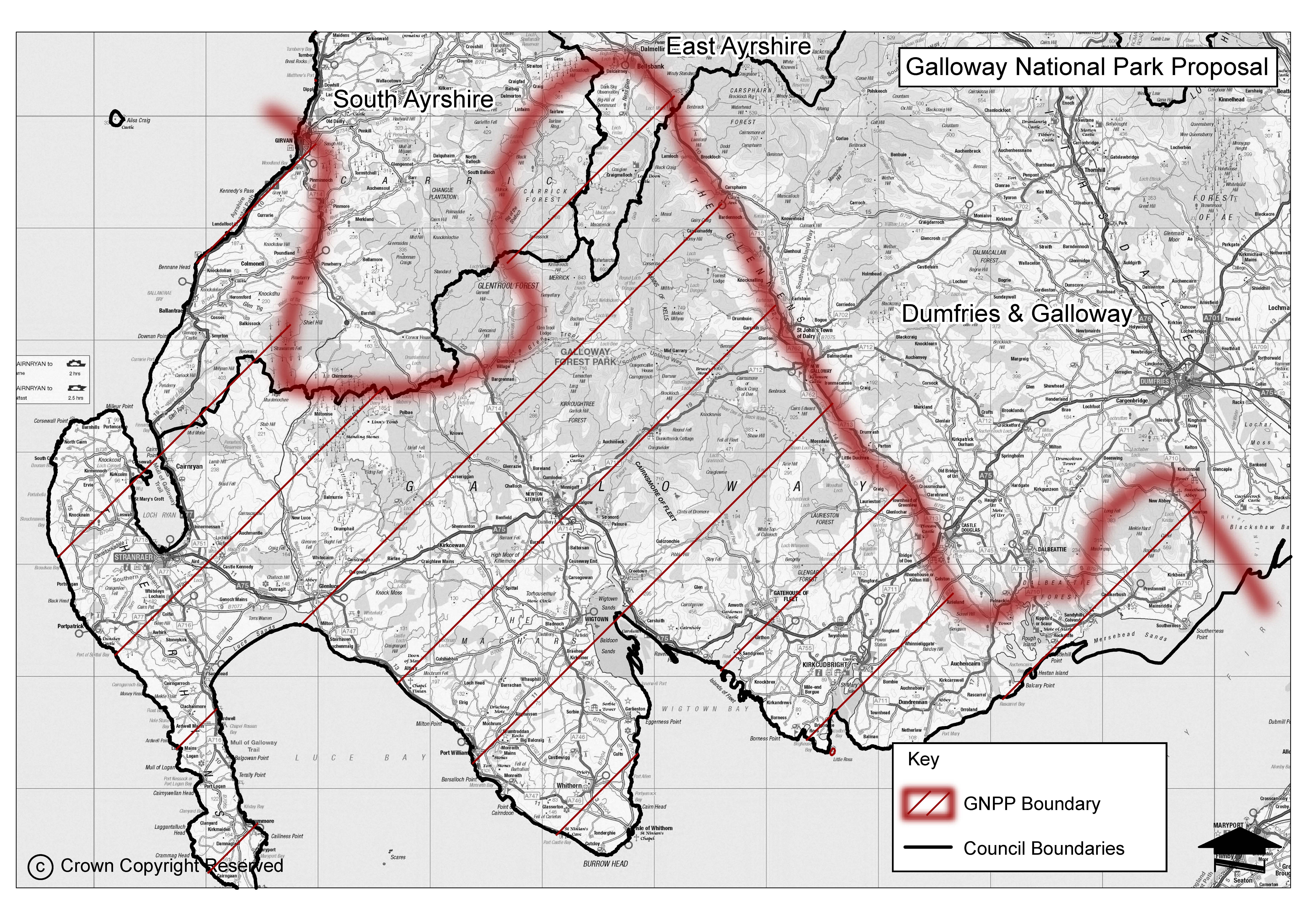
The second step was a desk-based review of the indicative area to divide it into a number of coherent sub-areas shown in Figure 1. Divisions were based mostly on landscape character, using the national dataset, as this provided appropriate elements and a suitable scale for this stage of the work. To ensure the work was comprehensive, the sub-areas extended beyond the indicative area identified in the bid. 18 sub-areas were initially identified which is in line with the level of detail used for assessing the existing National Parks areas (20 sub-areas were identified for Loch Lomond & the Trossachs and 29 for the Cairngorms). A provisional name for each sub-area was identified.
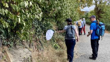
The third step was fieldwork, conducted over two weeks in late September and early October 2024, to assess each sub-area for its contribution to the three conditions of the Act. The fieldwork team of seven members of NatureScot staff was divided into four groups of at least two staff per fieldwork session, with a landscape architect involved throughout for consistency. The fieldwork also enabled a check on the validity of the draft sub-areas. As a result, 3 areas were amalgamated and 2 divided, reducing the number of sub-areas by one, to 17.
The fourth step was to consider the case for inclusion of each sub-area to provide the basis for identifying options for consultation using a five-fold ranking system from low to high as follows.
- Minimal
- Minor
- Partial
- Significant
- Extensive
The results of this exercise are shown in Table 2.
Several options could be produced from this exercise. After review, we decided to consult on three which showed the strongest overall fit with the legislative conditions and made sense in broad geographic terms. In Table 4-1 of the consultation paper we provide a short overview description of each of these options against the conditions of the Act.
| Option | Sub-areas |
|---|---|
| Hills and coasts | 7,8,9, 10,13 |
| Hills and extended coast | 1,5 7,8,9, 10,13, 14 and 15 |
| Hills, extended coast and countryside. | 1-15 |
All the options include the “hill” and “coastal” sub-areas we judge to be of highest natural heritage quality because of their current designation for nature conservation or landscape. The extent to which land is included beyond these sub-areas is a judgement about the character and coherence of the area and the scope to include sub-areas which collectively have the potential to deliver each of the National Park aims. The potential for nature recovery and the consideration of cultural heritage factors across these larger options is an important consideration too. There could be variations on the three main options in terms of the inclusion or exclusion of individual sub-areas or through the detailed consideration of the best boundaries for these options. Alongside views on the three options, we are therefore seeking comments on possible variations to them as part of the consultation.
As well as the knowledge of NatureScot staff, Historic Environment Scotland contributed information and expertise for the cultural heritage aspects which helped inform our assessment. Comments gathered from the discussions with stakeholders and the interactive map on the Information Hub during the engagement phase were also used to gather local opinions of special qualities and prominent issues across the bid area. Table 3 summaries these.
The fifth step is the consultation on the possible geographic options for the proposed National Park. This forms part of the overall formal consultation.
In the sixth step, we will review this assessment following comments received from the formal consultation and further discussion with Historic Environment Scotland and others. We will also undertake more detailed assessment of its natural systems and processes. This will inform preparation of finalised options for presentation to Scottish Government as part of our advice, due to be submitted in spring 2025.
| Legislative conditions | Components | Indicators | Notes for proposal for a National Park in south west Scotland |
|---|---|---|---|
| Outstanding national importance | Does the area contain nature conservation, landscape or cultural heritage interests of the highest national significance, extent and quality?
| Presence and extent of international, national and local designations for
| Compared to their natural heritage equivalents, historic environment designations tend to be much smaller and/or point features. Further discussion with Historic Environment Scotland will be needed to consider how these can be best be used in the assessment process alongside historic land-use assessment
|
| Outstanding national importance | Natural systems and processes – are they predominant in the sub-area? | Extensive areas of semi-natural habitat, dynamic river systems and processes. | Much of the area is highly modified, though it will be important to look at river catchments and coastal systems in refining a preferred area and its boundary. |
| Outstanding national importance | Do the special qualities of the area provide opportunities of national importance for enjoyment and understanding of the natural and cultural heritage? |
| Key features include national paths and trails (e.g. Scotland’s Great Trails, National Cyle Network); recreational facilities (e.g. Forest Park, Dark Sky Park, 7Stanes, etc.) and visitor attractions (e.g. HES, NTS, RSPB Logan RBGE outstation etc). |
| Distinctive character and coherent identity | What is the contribution to the distinctive character of the area? | Relative contribution of each sub-area to the overall character of Galloway or southwest Scotland. | Judged from bid, information available from landscape character assessment and historic land-use assessment and fieldwork. |
| Distinctive character and coherent identity | What is the contribution to the coherent identity of the area? | Relative contribution of each sub-area in terms of local traditions, sense of community identity and historical and artistic associations. | Judged from bid, information available from landscape character assessment and historic land-use assessment and fieldwork. |
| Special needs of the area | Are the threats to the natural, cultural heritage and recreational qualities of the area, or opportunities for their enhancement, sufficient to merit national effort and enhanced resources? |
| Judged on information available and provided through the contributions received during pre-consultation phase.
|
| Special needs of the area | Does the management of the natural resources of the area require the more integrated and specialised approach of a National Park? | Scale and significance of conflicts between different land uses, between land management activities and recreation use, and between different recreational uses. | Judged on information available and provided through the contributions received during pre-consultation phase.
|
| Special needs of the area | Are there likely to be specific social and economic benefits for the area of designation as a National Park? |
| Judged on information available and provided through the contributions received during pre-consultation phase.
|
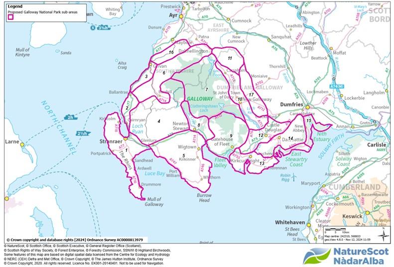
Figure 1 - Finalised Sub-divisions for investigating the indicative area.
Click for a full description
Open large version of map.
| Sub area | Provisional name | Outstanding national importance | Distinctive character and coherent identity of the area | Designation would meet special needs of the sub-area |
|---|---|---|---|---|
| 1 | The Rhins | Minor | Significant | Minor |
| 2 | Cairnryan to Ballantrae | Minor | Partial | Minor |
| 3 | Ayrshire coast | Partial | Minor | Minor |
| 4 | Wigtown and southern Ayrshire moors | Minor | Minor | Minor |
| 5 | The Machars | Minor | Significant | Minor |
| 6 | Ayrshire dales and foothills | Minor | Minor | Partial |
| 7 | Galloway Hills | Extensive | Extensive | Significant |
| 8 | Glen Trool, Cree valley | Significant | Significant | Significant |
| 9 | Cairnsmore of Fleet, Creetown | Extensive | Extensive | Extensive |
| 10 | Glenkens | Partial | Significant | Significant |
| 11 | Cairnsmore of Carsphairn | Partial | Partial | Minor |
| 12 | Dee Lowlands | Minor | Partial | Partial |
| 13 | East Solway Coast | Extensive | Extensive | Extensive |
| 14 | Coastal Hills | Significant | Extensive | Significant |
| 15 | Nith Estuary | Extensive | Extensive | Partial |
| 16 | Water of Girvan | Minor | Minor | Minor |
| 17 | East of Glenkens | Minor | Minor | Minor |
| Sub area | Provisional name | Valued most | Top issues raised |
|---|---|---|---|
1
| The Rhins |
|
|
| 2 | Cairnryan to Ballantrae |
|
|
| 3 | Ayrshire coast |
|
|
| 4 | Wigtown and southern Ayrshire moors |
|
|
| 5 | The Machars |
|
|
| 6 | Ayrshire dales and foothills |
|
|
| 7 | Galloway Hills
|
|
|
| 8 | Glen Trool, Cree valley
|
|
|
| 9 | Cairnsmore of Fleet, Creetown |
|
|
| 10 | Glenkens |
|
|
| 11 | Cairnsmore of Carsphairn
|
|
|
| 12 | Dee Lowlands |
|
|
| 13 | East Solway Coast |
|
|
| 14 | Coastal Hills |
|
|
| 15 | Nith Estuary |
|
|
| 16 | Water of Girvan |
|
|
| 17 | East of Glenkens
|
|
|


