Peatland ACTION - Species Surveys Guidance and Templates for protected species
https://nnr.nature.scot/doc/peatland-action-species-surveys-guidance-and-templates-protected-species
Species survey guidance and templates for field ecologists

Species survey guidance for field ecologists
Undertaking management and restoration work on Scotland’s peatland habitats will have long-term benefits for supporting a rich biodiversity as well as improving water quality and carbon storage. However, when undertaking restoration work, all parties involved must ensure that there are no negative impacts on protected species and that they stay within the constraints of the law.
Expand the accordions below for the species you are surveying to find out more about the legal and policy requirement's and how to conduct surveys prior to restoration commencement.
Caveat: This is not a full list of all the species that you may encounter on a peatland. All protected species must be recorded in your species survey form.
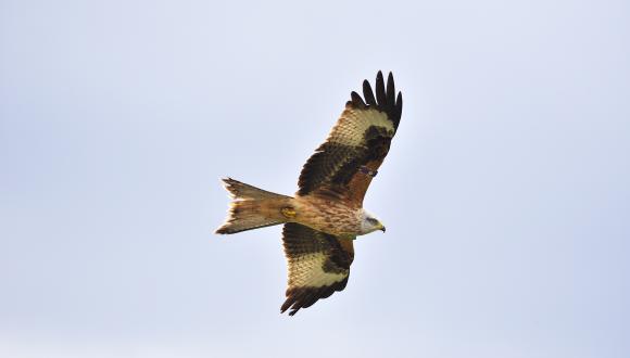
Peatland Restoration Guidance - Breeding bird survey
Undertaking management and restoration work on Scotland’s peatland habitats has the potential to conflict with Scotland’s wild birds breeding on these habitats.
Our guidance on peatland restoration and breeding birds sets out a protocol that all parties involved in peatland restoration are required to follow to ensure that they stay within the constraints of the law.
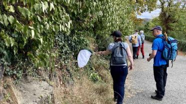
Peatland Restoration Guidance - Reptiles (ARG UK Advice Note 10)
Three reptile species (adder, common lizard, and slow-worm) are known to occur in Scottish peatlands. All native reptile species are protected under relevant national legislation, and are also included on the national lists used to define the Biodiversity Duty of public bodies in the UK.
Amphibian and Reptile Group UK Advice Note 10: Reptile survey and mitigation guidance for peatland habitats provides guidance on designing peatland restoration projects so as to avoid negative impacts on reptiles. A flow chart and summary table are provided to assist project planning.
Guidance on other protected species
See NatureScot's standing advice and documents for guidance on other protected species
Species survey GIS data templates
The Peatland ACTION Species Survey GIS Data Templates are for Field Ecologists to use to capture species survey data directly in the field on a tablet or smartphone app, or to digitise records from field notes after a species survey has been undertaken. Templates are available as both OGC Geopackage (.gpkg) for use with QGIS (preferred) and as a File Geodatabase (.gdb) for use with ESRI ArcGIS Pro. The Species Survey GIS Data Template Guidance document provides guidance on how to use these templates.
Species survey - Guidance on how to use the GIS Data Templates
1. Introduction
This GIS data template has been designed for species surveys and can be used to either capture data directly in the field on a tablet or smartphone app, or to digitise records from field notes after a species survey has been undertaken. Which of these methods chosen will determine how you use the template.
Templates are available as both OGC Geopackage (.gpkg) for use with QGIS (preferred) and as a File Geodatabase (.gdb) for use with ESRI ArcGIS Pro.
Users are free to export data to other formats such as ESRI Shapefile to fit their workflows, however - the data must be submitted to NatureScot Peatland Action as either OGC Geopackage or File Geodatabase. Data provided in other file formats will not be accepted.
The templates have been designed to enable consistent capture of data, as such, please do not alter the table schema – for instance by changing field names or adding new fields.
2. What the template aims to do
This is primarily a way to record and submit data. The template uses the British Trust for Ornithology (BTO) breeding evidence codes. The template also includes functionality to create a new layer that represents indicative disturbance zones around bird species listed on Schedule 1 of the Wildlife and Countryside Act 1981 that are considered probable or confirmed breeders. It is intended as a guide to surveyors, and they should refer to the individual species accounts in the guidance Disturbance Distances Review report and use their professional judgement to decide on an appropriate buffer. This will be necessary for those species where sufficient empirical data does not exist and that are not that are not included in the Disturbance Distances Review report. For example, dotterel is not covered in the Disturbance Distances Review report and does not trigger a disturbance buffer in this tool. However, as a Schedule 1 species under the Wildlife and Countryside Act, dotterel should be protected from intentional or reckless disturbance, while at a nest containing eggs or young, or with dependent young. Therefore, dotterel would need to be included in a species protection plan and the surveyor’s professional judgement would be required to define the disturbance buffer zone.
3. What is in the template
The template comprises four spatial tables, a non-spatial table and ten of lookup tables (which are used to populate dropdown options for some fields).
3.1 Spatial tables
Bird_records are edited in the field when species are encountered (or transcribed from field notes). The bird species list includes most of the species likely to be encountered, but it is not exhaustive. If bird species are recorded that are not on the list please use ‘Other (please specify in Notes)’ and add the species into the Notes field.
Mammal_records are edited in the field when species are encountered (or transcribed from field notes). The template currently allows records of Water Vole and Otter to be entered. Other relevant species data can be submitted to Peatlandspecies@nature.scot.
Survey_area is the boundary of the area surveyed and needs to be set up prior to going into the field. This can be edited in the field, if required.
Disturbance buffer table will display the output of the disturbance buffer workflow (see below). This workflow creates indicative disturbance buffers for species listed on Schedule 1 of the Wildlife and Countryside Act that have been recorded as probable or confirmed breeders.
3.2 Non-spatial tables
Survey_details should be entered in the relevant field to record the survey metadata; the survey_id, start time, end time, weather conditions etc. Survey_id should be an integer that corresponds to the visit number. The lookup tables (prefixed with ‘lu_’) are used by the QGIS project to populate the dropdown options for particular fields. The lu_bird_species comprises a list of most bird species likely to be encountered, with the breeding season start and end dates for species, where such information is available, and a disturbance buffer zone, where evidence is available in the disturbance distances of selected bird species.
4. Workflow
This GIS template can be used to capture data directly in the field (A), or to digitise records from field notes after a species survey has been undertaken (B).
A. If capturing data in the field with QField (or Mergin maps, ArcGIS Field Maps, ArcGIS Collector etc.)
- Draw your proposed survey area at your desktop in the template using the survey_area layer.
- Package the project for remote field collection.
- Open the project in the field.
- Complete the survey_details table, excluding end time which you can edit later.
- Complete the survey following the Peatland Restoration and Breeding Birds guidance or following best practice survey guidelines for the species being surveyed and record all species encountered.
- On completion of the survey, edit the pre-drawn survey area, if required.
- Complete the survey_details table adding the end time and making any required changes to weather variables etc.
- Synchronise the field data with desktop GIS.
- Generate indicative disturbance buffers (see below for further information).
- Make any amendments to the disturbance distance buffers where appropriate.
- Send the completed geopackage/geodatabase to Peatlandspecies@nature.scot
B. If digitising records from field notes after a species survey has been undertaken
- Carry out the field survey, collecting all of the relevant information to complete the survey_details table.
- In QGIS (or ArcGIS Pro), draw the area that was surveyed using the survey_area layer.
- Complete the survey_details table.
- Transcribe all bird and mammal records to the relevant layers (bird_records, mammal_records)
- Generate indicative disturbance buffers (see below for further information).
- Make any amendments to the disturbance buffers where appropriate.
- Send the completed geopackage / geodatabase to Peatlandspecies@nature.scot
5. Using the template for field data capture
Mobile data capture tools are available for both QGIS (preferred) and ArcGIS Pro – some recommended options include:
• Qfield
• Mergin maps
• ArcGIS Field Maps
• ArcGIS Collector
5.1 Multiple surveyors
If more than one surveyor is completing a survey on a site, the surveyors can contribute to the same survey area, or complete individual survey areas per surveyor. The survey data from multiple surveyors should be collated before running the disturbance buffer tool.
5.2 Generating the disturbance buffer
This section describes how to generate disturbance distance buffers for species listed on Schedule 1 of the Wildlife and Countryside Act 1981 that are considered probable or confirmed breeders. The process for both is detailed below. Note – this buffer should only be considered a starting point and should not be a substitute for professional opinion. There may be various factors such as topography where it may be appropriate to adjust the buffer.
If mammals are recorded and a buffer for mammals is needed, use the default buffer tool in QGIS or ArcGIS to generate an appropriate buffer. Copy the outputs into the disturbance buffer table.
5.3 QGIS
The QGIS template includes a tool generated for the purpose. The tool is saved within the QGIS project file (species_survey_template.qgz) and can be found in the processing toolbox. The tool has been developed using QGIS 3.22, it is recommended to use the latest Long Term Release (at time of writing 3.22) for compatibility. Older versions of QGIS may not run the tool correctly. To find the tool, use the processing search bar or go to the processing tool box and then “Project models” and “Disturbance buffer tool”. See figure 1. Tool requirements.
The disturbance buffer tool requires that each row of the bird_records table has the species and breeding_behaviour_evidence field completed. These fields are used by the tool to lookup the relevant species to assign a disturbance buffer.
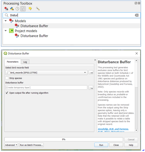
Figure 1 - Screenshot of Customized Disturbance buffer tool in the Peatland ACTION species survey QGIS
Once completed, select the table containing your bird records, you can also choose to strip species information from the output buffer. This may be appropriate when dealing with sensitive species records. Note that with either option, a relationship will remain between the output buffer and the records table through the auto generated UUID field.
Once happy with the options, run the tool and the output disturbance buffer will be created. Copy the results into the disturbance buffer layer.
5.4 ArcGIS Pro
The data model can also be completed using ArcGIS Pro, the project was created using ArcGIS Pro 2.9 – for compatibility it is recommended to use at least version 2.9 or newer.
There is not a customized tool in ArcGIS Pro template, but the default buffer tool can be used in this instance as described. The bird_record table is configured using a join to the lu_bird_lookup and lu_breeding_evidence tables. Open the attribute table of the bird_record and you can filter by breeding status and schedule 1 status. Select only species that are listed as Schedule 1 and have a breeding status as “probable” or “breeding”. Use the default buffer tool in ArcGIS Pro and use as buffer_zone the field to buffer the features by. See figure 2. A new polygon will be generated, copy the results from that polygon into the disturbance buffer layer.
ADD IMAGE / FIGURE - Need long description
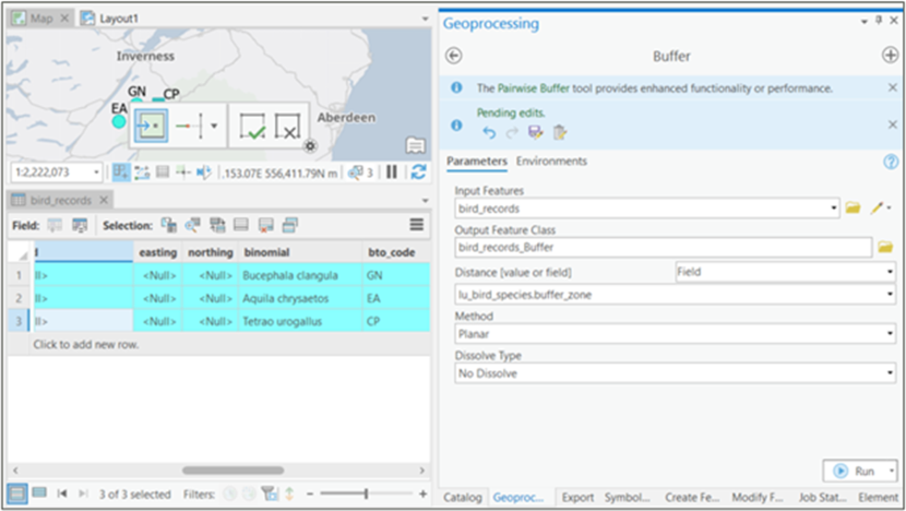
Figure 2 - Screenshot of Default buffer tool in Peatland ACTION species survey ArcGIS Pro. Use as distance value the field "buffer zone".
6. Outputs
6.1 Data Submission
During the active restoration works phase all bird survey data using Peatland ACTION’s Species Survey GIS template in the form of a PDF using the print map layout template and a species list in an excel spreadsheet should be submitted to Peatlandspecies@nature.scot within 48 hours of the survey. All survey data should be sent as either OGC Geopackage or File Geodatabase (data provided in other file formats will not be accepted) along with any accompanying reports and Species Protection Plans to Peatlandspecies@nature.scot within one week of the survey being completed.
6.2 Species List in Excel
Please, use the excel template provided and do not alter any columns or sheet order or names. The excel spreadsheet needs to contain two sheets (apart from the info sheet), one called bird_records and the other one called survey_details. The bird_records sheet needs to have the next columns fid, survey_id, species, count, breeding evidence, notes, uuid, easting and northing. The survey_details sheet needs to have the fid, survey_id, survey_area_id, survey_date, suvey_start, survey_end, surveyor_name, coverage, visibility, cloud_cover, rain, wind_force, snow_cover, weather_affected_notes. The recommend workflow is to export the bird_breeding layer to excel or csv and also the survey_details. Then, copy the content of the exports into the template.
6.3 Print Map Layout
A print map layout template is provided for both, ArcGIS and QGIS. Please create a map to an appropriate scale and export ii as a GeoPDF.
6.4 Outputs Checklist
• Make sure that the Survey IDs for survey details table and the rest of the tables (survey area, disturbance buffer, bird records and mammal records, are consistent).
• Check that the disturbance buffer has been generated (if there are birds categorise as such).
• Once the bird breeding table is completed, check that easting and northing coordinates has been generated.
• Survey dates are consistent between the survey details table, the title on the survey print map layout and the excel spreadsheet table.
• Make sure that the excel spreadsheet contains just the columns requested and the column names and tab names have not been changed.
• Geodatabase (if using ArcGIS pro) and Gepackage (if using QGIS) just contain the original layers and they have not been altered. The geodatabase in ArcGIS Pro is the one called “species_survey.gdb”.
• Make sure you use the same data types on the excel spreadsheet as the ones used on the spatial data templates.
7. Other Reporting Requirements
Please note, that observations of any active nest sites of non-Schedule 1 bird species found within 500m of the working area or any active nest sites of a Schedule 1 bird species that are found within the accepted disturbance distances defined in the Disturbance distances review report and any required mitigation must be reported via email to the Peatlandspecies@nature.scot mailbox, the relevant Project Officer and the works contractor within 24 hours. Where possible, disturbance buffer zones should be marked out on the ground with the contractor. Similarly, observations of any other protected species found during the active restoration works phase that could be impacted by the works and mitigation requirements must be reported via email to the Peatlandspecies@nature.scot mailbox, the Peatland ACTION Project Officer and the contractor within 24 hours to ensure appropriate action is be taken to avoid any impact to protected species.
Species Protection Plan Templates for birds
Species Protection Plan Template for birds are available in the document downloads section of this web page.
Document downloads
Last updated: