Peatland ACTION: Spatial data guidance in support of your project

The spatial data associated with your restoration project is important to Peatland ACTION so that we can assess restoration plans at the start of a project and report the outcomes at the end. They are also used for monitoring the effectiveness of restoration activities.
To use these data effectively, we need them to be submitted in a consistent format. To achieve this, we have created an updated set of spatial data templates (geopackage and file geodatabases) along with project files for popular GIS software - QGIS (free), and ArcGIS Pro (proprietary). These can be downloaded below.
Also included in the zip files are the metadata form and guidance documents to assist you in completing and submitting this data.
Your Peatland ACTION Project Officer will be able to provide advice and assistance peatlandaction@nature.scot
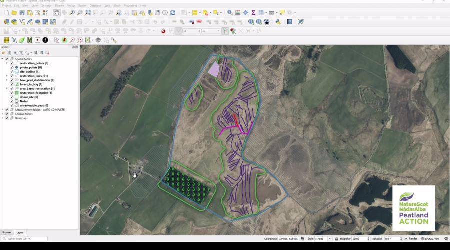
An example of some spatial data provided in support of a Peatland Action final report is shown in the web map below.
Spatial data template packs (zip files) - updated 06 August 2024
Spatial data template packs (zip files) - updated 06 August 2024 – please ensure you use the most current version.
Peatland Action - GIS Template - ArcGIS - August 2024 (Zip file)
Peatland Action - GIS Template - QGIS - August 2024 (Zip file)
Peatland ACTION - Restoration footprint - What are they and how to draw them - Guidance
The restoration footprint is used to calculate the area (in hectares) included within the project. These areas are used by Peatland Action to report to the Scottish Government on the total area of peatlands “put on the road to recovery” in a financial year. It is therefore very important that all applicants are therefore providing this boundary consistently so we can be confident in our evidence.
All the information you need is provided on our Restoration footprint guidance page
Peatland ACTION - Final report template
A summary report must be submitted for each practical peatland restoration project funded by Peatland ACTION once work is completed. These reports are a requirement of the Peatland ACTION funding.
Video guides to help you draw your spatial data maps
When applying for Peatland ACTION funding applicants must submit digital maps of the proposed restoration work within the Peatland ACTION spatial data template alongside the application form and other documents. As part of the condition of funding applicants also need to submit spatial data at the project completion stage - this must accurately represent the work undertaken on the ground.
This series of videos sets out some of the key processes to help applicants, contractors and agents create accurate and consistent spatial data maps for Peatland ACTION restoration projects using the Peatland ACTION spatial data templates.
Peatland ACTION Spatial Data Templates Video 1 Introduction
Click for a full description
Duration
05:44
This video shows how to find the spatial data template zip packs on the NatureScot Peatland ACTION web pages and discusses the different download options. It goes on to provide an overview of what’s in the data pack including the three guidance PDFs. For more information: https://www.nature.scot/PeatlandACTION
Peatland ACTION Spatial Data Templates Video 2 Setting up the template
Click for a full description
Duration
07:00
This video shows how to find the spatial data template zip packs on the NatureScot Peatland ACTION web pages and discusses the different download options. It goes on to provide an overview of what’s in the data pack including the three guidance PDFs.
Peatland ACTION Spatial Data Templates Video 3a Site outline
Click for a full description
Duration
03:49
This video shows how to add a feature to the site outline layer within the template. Note, the site ID is a mandatory field within the other layers in the spatial tables group and therefore a site outline must be created first.
Caption
Peatland ACTION Spatial Data Templates Video 3b Restoration Lines
Click for a full description
Duration
08:11
Description
This video demonstrates how to add features to the restoration lines layer within the spatial data template. This layer is one of the most widely used layers and is often used to represent linear erosion features such as drains, hags and gullies.
Peatland ACTION Spatial Data Templates Video 3c Restoration Areas
Click for a full description
Duration
07:47
This video covers how to add a new feature to the area based restoration layer within the spatial data template. Techniques often visualised using this layer include different bunding, micro erosion repair and scrub removal. Note that whilst it is possible to use the area based restoration layer to map out features such as hags and gullies, we generally recommend that these are digitised into the restoration lines layer as described in video 3b.
Peatland ACTION Spatial Data Templates Video 3d Bare Peat Stabilisation
Click for a full description
Duration
07:27
This video shows how to add a feature into the bare peat stabilisation layer in the spatial data template. This layer is often used to represent areas of mulch, turving and sphagnum transplanting. Note that donor sites are required to be provided in the donor site layer for the two transplanting techniques and turving.
Caption
Peatland ACTION Spatial Data Templates Video 3e Forest to Bog
Click for a full description
Duration
04:25
Description
This video covers how to add a feature into the forest to bog layer in the spatial data template. Important information to input into this layer includes the previous woodland cover (e.g. coniferous, broadleaf or mixed) and the restoration technique. Stump flipping, furrow blocking and ground smoothing are all techniques that can be applied within the forest to bog layer.
Peatland ACTION Spatial Data Templates Video 3f Unrestorable peat
Click for a full description
Duration
08:29
This video highlights the changes to the unrestorable peat layer in the latest version of the spatial data template and new requirements of this layer. It demonstrates how to add features into the unrestorable peat layer, both by drawing a new polygon feature and by buffering a linear restoration feature such as a hag where restoration is considered inappropriate (e.g. naturally revegetating).
Peatland ACTION Spatial Data Templates Video 4 Restoration Footprint
Click for a full description
Duration
07:00
When applying for Peatland ACTION funding applicants must submit digital maps of the proposed restoration work within the Peatland ACTION spatial data template alongside the application form and other documents. As part of the condition of funding applicants also need to submit spatial data at the project completion stage - this must accurately represent the work undertaken on the ground. This series of videos sets out some of the key processes to help applicants, contractors and agents create accurate and consistent spatial data maps for Peatland ACTION restoration projects using the Peatland ACTION spatial data templates.
This video explains how to use the inbuilt buffer tool to create a restoration footprint once the mapping for a site has been completed. It also references the unrestorable peat layer and demonstrates how you can add areas which have been trimmed out of the footprint into this layer
Peatland ACTION Spatial Data Templates Video 5 Copying data into the template
Click for a full description
Duration
07:00
This video explains how to copy data into the spatial data template from other sources such as field data collected on site or outputs from automated processes. The process of copying and pasting data in from other datasets increases the risk of data errors, and therefore it is always recommended to package up the template for the field where possible.
Peatland ACTION Spatial Data Templates Video 6 Editing Data
Click for a full description
Duration
09:09
This video provides a few examples of how to edit data within the spatial data template. It covers both editing attribute values of a feature or a selection of features as well as editing the geometry of features.
Peatland ACTION Spatial Data Templates Video 7 Self QA
Click for a full description
Duration
11:09
This video offers some hints and tips on what checks you can undertake prior to submitting your spatial data as part of your Peatland ACTION funding application. This includes how to use the three Self QA tables in the template, how to identify and remove duplicates as well as checking for geometry errors.
Peatland ACTION Spatial Data Templates Video 8 Measurement Tables
Click for a full description
Duration
07:57
This video explains how you can use the tables within the measurement tables (autocomplete) group to fill out the application form or final report documents. Examples are provided for copying across data from the GIS project to the application form from the site outline table and the measurement tables which sum the total lengths, areas and counts of the features in the spatial tables. Please note that the numbering of the application form has been updated since this video was recorded and the two sections which are discussed in the video are now sections 43 and 44.
Peatland ACTION Spatial Data Templates Video 9 Useful Resources
Click for a full description
Duration
05:57
This video is designed to provide an overview of some of the data which is available to help you design and map a restoration project for Peatland ACTION funding. OS maps are available to download from the datahub (https://osdatahub.os.uk/) and if you are undertaking work on behalf of NatureScot then we can help you access any layers you may need. The open topo map is a free source that can be added to your GIS project to provide contour information. Other elevation data includes DTM, which is freely available from the remote sensing portal (https://remotesensingdata.gov.scot/) but coverage is currently limited. Aerial photography sources include Bluesky GetMapping APGB (https://www.apgb.co.uk/products) and freely available datasets such as google maps and bing satellite. The Scottish Government GIS layers can be found at the Spatialdata.Gov.Scot website (https://spatialdata.gov.scot/geonetwo.... Finally the peatland restoration work undertaken by peatland ACTION to date is available for download from the NatureScot open data hub (https://opendata.nature.scot/search?g...) or alternatively you can visit the Peatland ACTION Data portal (https://www.nature.scot/climate-chang... ), operated by an AGOL viewer, to review the datasets without downloading them (ideal for those without GIS software).
Last updated: